# Critical Elements Provides Assay Results on Its 10,000-Metre Drill Program at Rose West *2026-04-29T06:00:00-04:00* Critical Elements Provides Assay Results on Its 10,000-Metre Drill Program at Rose West **MONTRÉAL, QC / [ACCESS Newswire](https://www.accessnewswire.com/)/ April 29, 2026 / **Critical Elements Lithium Corporation (TSXV:CRE)(US OTCQX:CRECF)(FSE:F12) (**"Critical Elements" **or the **"Corporation") **is pleased to provide assay results and an update on its Phase 1 Winter 2026 drill program, at the 100% owned Rose West Discovery ("**Rose West**"), located in Eeyou Istchee, Québec. **Highlights** - The Phase 1 Winter 2026 drill program has successfully expanded the Rose West mineralized footprint from 450 m x 370 m to 1250 m x 800 m, demonstrating thicknesses that typically range from 10 to 40 m, and excellent lateral continuity. - Three new spodumene-bearing pegmatitic bodies have been identified within the target area in recent drilling. Bodies are stacked and generally flat lying. - The geological model is proving to be highly effective and productive. - An additional nineteen new holes have been completed with assays pending from six holes. Assay results were received for holes **RW-26-31 to 33, **and **RW-26-46 to 50**, and returned some significant lithium and tantalum composite assays, as highlighted: - **1.89% Li2O **and**207 ppm Ta2O5**over**13.50 m,**through **Pegmatite 3**, in hole RW-26-32 - **1.29% Li2O **and**169 ppm Ta2O5**over**17.75 m **(including **2.13% Li2O **and**105 ppm Ta2O5**over **9.00 m**)**, **through**Pegmatite 3 **in hole RW-26-33 - **0.93% Li2O **and**291 ppm Ta2O5**over**10.45 m **(including **2.75% Li2O **and**553 ppm Ta2O5**over **3.00 m**)**, **through**Pegmatite 5 (new), **in hole RW-26-46 - **2.18% Li2O **and**68 ppm Ta2O5**over**12.60 m **(including **3.11% Li2O **and**48 ppm Ta2O5**over **7.40 m**)**, **through**Pegmatite 3, **in hole RW-26-46 - **1.72% Li2O **and**117 ppm Ta2O5**ove**r 10.30 m **(including **2.61% Li2O **and**117 ppm Ta2O5**over **6.35 m**)**, **through**Pegmatite 5 (new), **in hole RW-26-47 - **1.91% Li2O **and**74 ppm Ta2O5**over**11.75 m,**through **Pegmatite 3**, in hole RW-26-47 - **1.13% Li2O **and **109 ppm Ta2O5**over**12.90 m,**through **Pegmatite 7 (new)**, in hole RW-26-50 _* Core length; the true thickness is between 80 to 95% of the core length._ Rose West is situated within 10 km of the highly advanced Rose Lithium-Tantalum Project ("**Rose**"). Rose West is a near surface lithium-rich pegmatite bearing zone, initially intercepted by drilling over a 450 m x 370 m footprint area in the winter of 2024 (see [Press Release dated February 3, 2026](https://pr.report/l4ms)), now covering an overall footprint of 1,250 m x 800 m. The lithium-rich pegmatites typically range from 10 to 40 m in thickness and display a sub-horizontal geometry. Recent drilling has identified three (3) new spodumene-bearing pegmatitic bodies within the target area; a significant addition to the working model as it could potentially lead to rapid growth of the mineral inventory within the footprint of the project. To date, the Winter 2026 drill program has covered most of the Line A, Line E and Line K planned holes (**Figure 1**). As previously mentioned, holes were planned to reach three specific goals: 1. Expand laterally all around the existing mineralized footprint (RW-26-29 to 34, RW-26-45 & 46); 2. Test the area for continuity to the northeast (RW-26-47 to 50), to the southeast (RW-26-40 to 44); 3. Verify the potential of discovering additional lithium-bearing pegmatites below the currently defined area. **Figure 1**below presents the 2026 collars location with, as well as the revised footprint on surface of the interpreted spodumene-rich pegmatitic dykes. Nineteen (19) holes have been drilled to date for a total of 4,037.75 meters. **Table 1**presents the collar locations along with final length and the azimuth / dip of the holes drilled during this campaign. **Figure 1**: Location map of the 2026 drillholes with respect to those from the winter 2024 campaign. [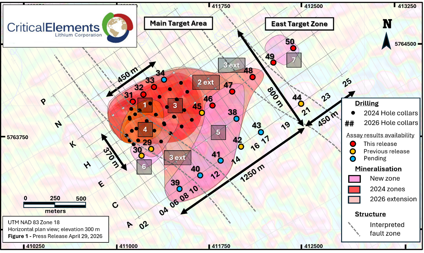](https://app.accessnewswire.com/imagelibrary/20d122be-ac0d-4e00-a3d4-a16b32099248/1162284/picture5.png) | **Drillhole** | **Grid** | **UTM NAD 83 ZN18** | **Length** | **Azimuth** | **Dip** | | | --- | --- | --- | --- | --- | --- | --- | | | **Position** | **Easting** | **Northing** | **(m)** | **(°)** | **(°)** | | **RW-26-29** | E-08 | 411277 | 5763656 | 207 | 245 | -80 | | **RW-26-30** | E-06 | 411195 | 5763599 | 72 | 245 | -70 | | **RW-26-31** | K-10 | 411129 | 5764041 | 126 | 245 | -70 | | **RW-26-32** | K-11 | 411211 | 5764098 | 165 | 245 | -70 | | **RW-26-33** | K-12 | 411293 | 5764156 | 287.7 | 245 | -70 | | **RW-26-34** | K-13 | 411375 | 5764213 | 147 | 245 | -70 | | **RW-26-38** | C-16 | 411965 | 5763893 | 218.9 | 245 | -70 | | **RW-26-39** | A-08 | 411506 | 5763328 | 262.35 | 24